New Jersey Hyperscale Data Center Campus - 550 MW Case Study
The Hyperscale Data Center Project in New Jersey
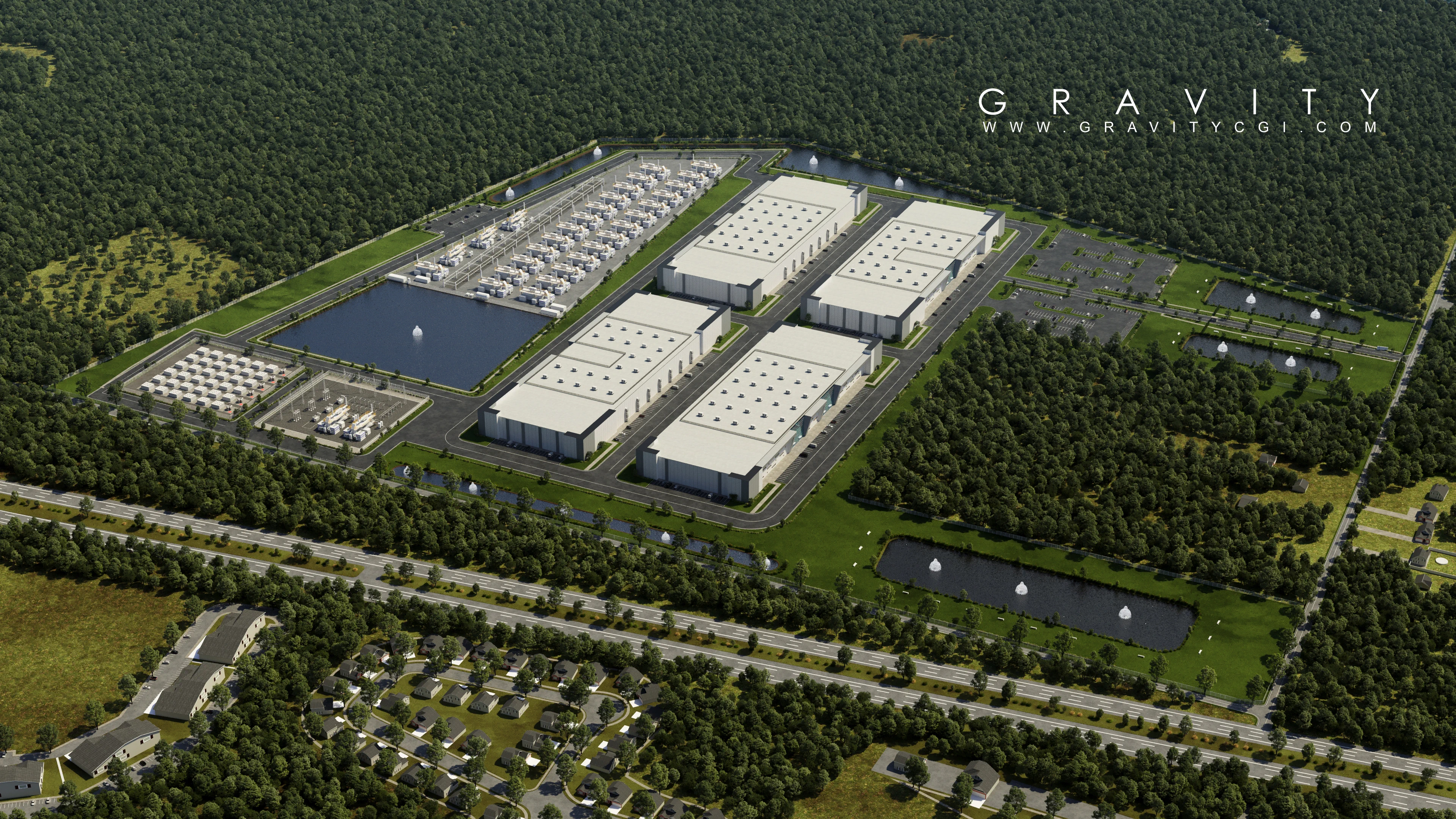
This concept study models a New Jersey data center campus targeting 550 MW of load capacity. The scenario focuses on a 122-acre core development envelope with integrated power and resiliency infrastructure, including on-site fuel cells, battery energy storage, and substation planning.
Using the Vineland planning benchmark of 13.0 MW per acre (30.76 acres supporting 400 MW), the campus scales to an estimated 42.3 acres of data center building footprint for the target 550 MW program.
Project Context: Why This Data Center Visualization Mattered
In today’s AI and cloud infrastructure race, data center developers need visual tools that communicate technical strategy quickly. This New Jersey hyperscale campus required one coherent visual language for multiple audiences: investors, utility partners, consultants, and planning stakeholders.
The render package was designed to translate complex systems into decision-ready visuals. Instead of fragmented diagrams, the aerial storytelling approach showed compute zones, energy assets, stormwater strategy, and movement corridors in one view. That clarity helps reduce ambiguity during pre-development discussions.
Infrastructure Clarity
Power generation, storage, substation areas, and drainage systems are visually separated for faster technical review.
Stakeholder Alignment
A single visual framework helps non-technical decision makers understand capacity and land-use tradeoffs.
Presentation Readiness
Output is suitable for investor decks, utility coordination meetings, and internal planning workshops.
Land Use, Power Density, and Capacity Planning
Gravity CGI structured the aerial siteplan to clearly communicate land-use balance between compute capacity, utility systems, circulation, and environmental controls:
- Data center buildings: 42.3 acres (34.7%)
- Fuel cells: 21.0 acres (17.2%)
- Substation: 2.5 acres (2.0%)
- Battery storage: 2.5 acres (2.0%)
- Stormwater management: 12.6 acres (10.3%)
- Parking and roadways: 20.8 acres (17.0%)
- Green spaces: 20.3 acres (16.6%)
Aerial Siteplan Rendering Deliverables for Data Center Development
- Masterplan aerial renders to communicate campus scale, building massing, and infrastructure hierarchy at a glance
- Presentation-ready visualizations for stakeholder meetings, utility coordination, entitlement discussions, and pre-development approvals
- Clear zoning of critical systems (generation, storage, drainage, and circulation) to support technical review and investor communication
Visualization Workflow Used for This Hyperscale Campus
To keep the case study technically credible and communication-friendly, the visualization workflow followed a structured pipeline from planning assumptions to polished render outputs.
- Input Consolidation: Site geometry, capacity assumptions, and infrastructure zoning were aligned before scene build.
- Massing and Allocation: Building footprints and utility parcels were blocked to reflect power-density logic.
- System Layering: Fuel cells, battery storage, substation zones, circulation, and stormwater areas were integrated with clear spatial hierarchy.
- Presentation Polish: Camera framing, environmental context, and annotation-ready composition were optimized for executive communication.
This process is especially effective for data center site plan rendering, masterplan visualization, and technical investor presentations where visual clarity drives decisions.
Business Impact and Strategic Value
This case demonstrates how technical rendering supports faster project momentum in large-scale infrastructure programs. For hyperscale teams, visuals are not just marketing assets; they are coordination tools that reduce friction across planning, financing, and technical review cycles.
- Improves confidence during early-stage investor and partner conversations
- Helps cross-functional teams validate land-use balance and infrastructure logic
- Supports stronger communication for phased expansion and utility strategy
- Creates reusable visual assets for proposals, approvals, and outreach
For firms searching for hyperscale data center rendering or AI infrastructure visualization services, this project shows how high-clarity aerial renderings can make complex technical intent easier to understand and evaluate.
Services Used
FAQ: New Jersey Data Center Visualization
What is the target capacity of this New Jersey data center campus?
The campus targets 550 MW of IT load capacity within a 122-acre core developable envelope.
How was the 42.3-acre building footprint calculated?
The footprint is scaled from a 13.0 MW-per-acre benchmark, resulting in 42.3 acres of data center buildings for a 550 MW program.
What infrastructure systems are shown in the aerial render?
The plan includes fuel cells, battery storage, a substation zone, stormwater management basins, roads, parking, and green buffers.
Can this visualization be used in investor or utility presentations?
Yes. The render package is structured for stakeholder communication, utility coordination, and early-stage planning approvals.
Who typically uses this type of hyperscale data center rendering?
Developers, EPC teams, engineering consultants, utility stakeholders, and investor groups use this visualization format to align strategy and speed up decisions.
Why is aerial siteplan rendering important for AI-ready infrastructure campuses?
Aerial views communicate scale, power systems, and environmental controls in one visual frame, making complex infrastructure easier to evaluate for both technical and non-technical audiences.
Need Investor-Ready Technical Visuals?
Get a free quote within 24 hours - no obligation.
Book Your Free Strategy Call